Photo Credit:
Katie Reynolds | IG: @planet.katie | Original Post: August 19, 2021
At a Glance:
| Location: | National Forest Development Road 7601 Leavenworth, WA |
| Trail or Landmark Name / Map: | Colchuck Lake |
| Parking Coordinates: | 47.527905, -120.820616 |
| Photo Coordinates: | 47.498353, -120.833349 |
| Distance: | 9 miles round trip, Out-and-Back |
| Time to Complete: | 6-8 hours |
| Difficulty: | Hard |
| Elevation Gain: | 2,283 ft |
| Quick Facts: | ✔ Entrance Fee: $5 / car ✔ Restrooms Available ✖ Kid Friendly ✖ Wheelchair Accessible ✖ Dog Friendly ✖ Bike Friendly |
Description:
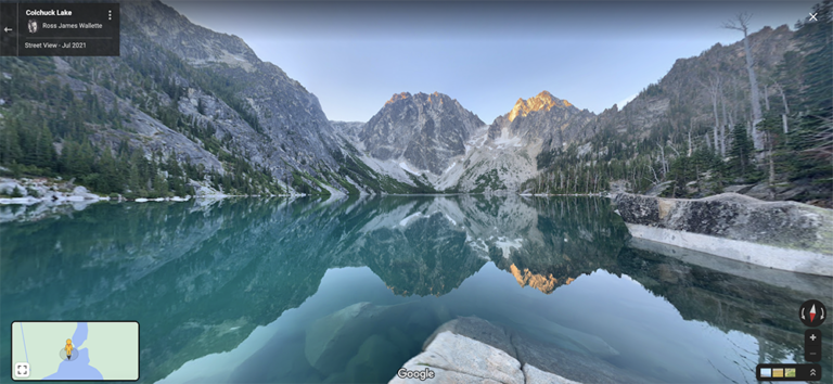
The photographer took this photo on August 15, 2021 around 10:00 AM. Once you reach the end of the main trail, you will need to hike clockwise around to the north side of the lake to see this particular view, using some less-well-marked side trails.
Colchuck Lake is a challenging, 9-mile round trip hike with some steep, rocky sections and tree roots. Hiking poles are highly recommended, especially for the way down. Most people take about 6 hours to complete this hike (3 hours up, a little less down, plus some time spent up at the lake). The elevation gain of 2,283 ft in only 4.5 miles is tough, but manageable.
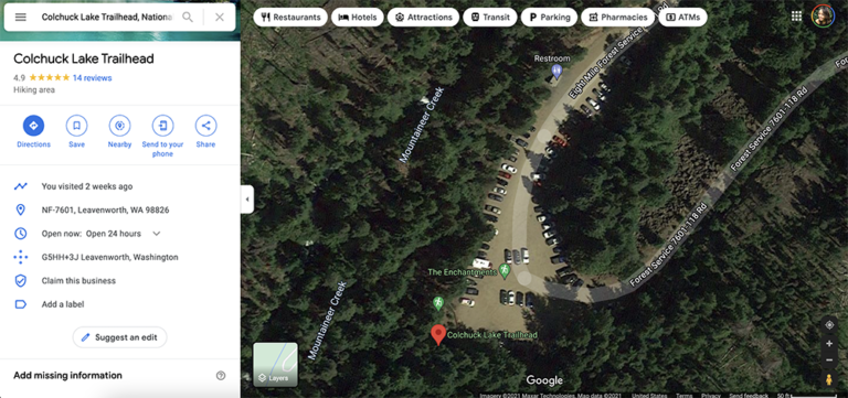
Google Map to “Colchuck Lake Trailhead, National Forest Development Road 7601, Leavenworth, WA“. Note that the road leading up to the trail is VERY bumpy and full of potholes (for about 5 miles). You can make it in a sedan if you take it very slowly, but an SUV or truck are highly recommended. You will arrive at a parking lot which often fills up shortly after sunrise, as hikers like to get an early start to avoid the heat and mosquitoes in the summer.
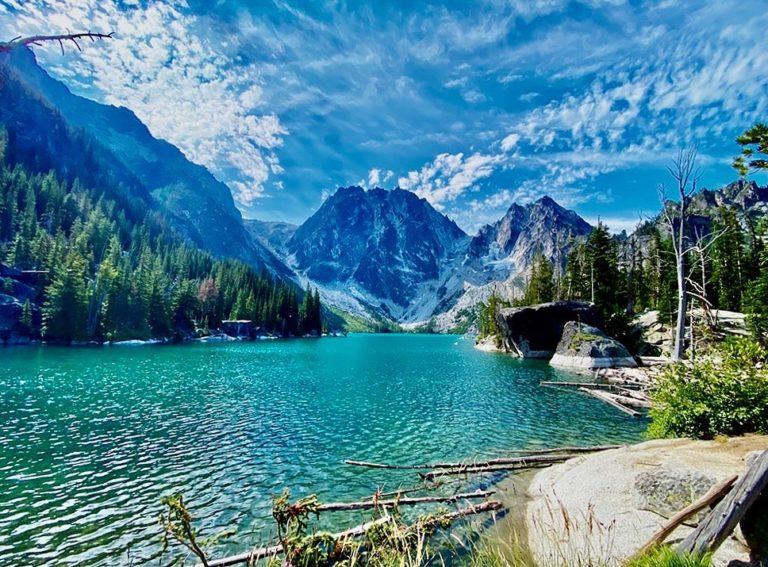
The path to the lake is fairly well marked. After a couple of relatively easy miles, you will cross a bridge over the creek and start the real inclines. There is a trail junction shortly after. Be sure to take the left fork to Colchuck Lake, as the right will lead you to Stuart Lake. After crossing a log bridge, continue up the steady rocky inclines for another couple of miles. The last mile is the toughest, but the payoff is well worth it when you finally round the corner and see the gorgeous turquoise Colchuck Lake for the first time.
There are many side trails that lead down to the lake, but there isn’t much room to spread out at the bottom. Most side trails lead straight down to a small opening with a few rocks on the lake. There isn’t a wide bank to spread out a picnic blanket and it could take you several tries to find an opening that isn’t already occupied by another party, so be prepared to hike a little more once you reach the top. If you go clockwise along the lake from the top of the main trail, you will find the best unobstructed views of the whole lake with the mountains in the background.
Once you find a spot to chill, be sure to take a dip in the refreshing, 45° water! It can be a shock at first but is surprisingly easy to get used to after a couple of minutes, especially in the hot sun after a strenuous hike.
Helpful Links:
Additional Images: